What the evidence shows
Public records establish a long history of intersection planning and several transport and utility projects affecting the same road network. They support a serious question about the cumulative effect on people who live, travel and do business here. They do not establish that every project could have been built together, or that every day since the first works has involved a closure.
Council papers identified a Mairehau/Burwood intersection upgrade more than a decade ago. [1]
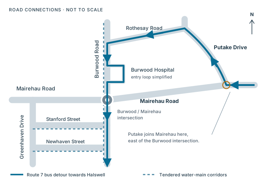
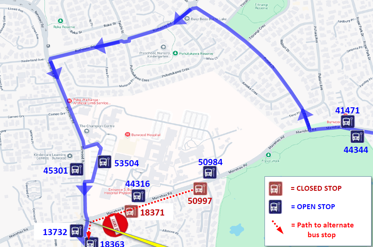
Metro lists a westbound Route 7 diversion via Putake Drive, still without a published end date at this review. [14]
The roundabout-to-signals conversion has been deferred, according to the local programme information available to me. [17]
The 2025 consultation contains a local business’s account of repeated roadworks affecting its operation. It is testimony, not a sales audit. [15]
Council’s consultation page still gives summer 2026/27 as its construction target. The more recent local information is that the conversion has moved to later in 2027. I retain that update here, while making its source clear; a dated public notice confirming the revised programme is not available in the sources linked below. A revised start period also does not establish a completion date. [10] [17]
The roads and the diversion
Putake Drive joins Mairehau Road east of the Burwood intersection and runs north towards Rothesay Road. The earlier schematic incorrectly showed it branching from the roundabout. The corrected diagram follows the connections shown in Metro’s detour map. [16]
Water works extend onto the adjoining streets
The 2024 water-main tender covers Burwood Road from Mairehau Road south to the pump station at 168E Burwood Road, and north towards Nederland Avenue/Rothesay Road. It also covers Stanford and Newhaven streets between Burwood Road and Greenhaven Drive. This establishes the geographic scope; it does not supply a complete history of traffic restrictions. [4]
Putake repairs overlap the bus-diversion period
Council’s notice schedules initial surface repairs between Puhara Avenue and Titirangi Crescent for 31 August–7 September 2026, subject to weather and site conditions. Final surfacing is a separate stage that Council says may follow up to 12 months later. The notice specifies contraflow traffic, a 30 km/h limit, restricted parking and limited property/workplace access. Footpaths within kerb-and-channel work areas are also to close. These are concrete access constraints, even though the road itself is not listed for full closure. [13]
The dates overlap the published bus diversion. That warrants a question about coordination, but the two notices alone do not measure delays or demonstrate that the detour became unusable.
Metro confirms the diversion for Route 7 towards Halswell and says its eastbound service is unaffected. The diverted service still returns via Burwood Road and the hospital to the intersection. The notice does not establish the routes taken by all private vehicles or the number of customers passing a shop. [14]
Planning and works: a sourced timeline
Planning dates, funding allocations and construction periods describe different things. This timeline keeps them separate. In particular, a tender award or an annual budget does not establish the start and end of road closures.
| When | What the record says | Evidence and limits |
|---|---|---|
| 2013 | Growth-infrastructure papers list a Mairehau/Burwood intersection upgrade with a proposed July 2015 completion. | PlanningA historic proposal, not proof that today’s scheme was ready to construct. [1] |
| 12 Sep 2019 | Council sought advice on funding the intersection safety project earlier through the 2020/21 Draft Annual Plan. | ResolutionA request for advice, not a construction contract. [2] |
| 2023/24 | The capital programme lists Mairehau corridor improvement (42010) and Burwood/Stanford/Newhaven water-main renewals (70894). | Budget recordConfirms both projects were in the programme. [3] |
| Oct 2023–Sep 2024 | The earlier local account places Mairehau/Prestons Park works in this period, with an April 2024 expectation later revised to September. | Local historyThe underlying dated work and developer notices were not available for this review. [17] |
| 14 Aug 2024 | The water-main tender was awarded to Trenching Dynamix. | ProcurementAward date; closure dates are not specified. [4] |
| 11 Mar 2025 | The earlier account records a six-week roundabout works stage. | Local historyOriginal work notice not available to link. [17] |
| 2025/26 funding | The adopted plan allocates NZ$1.2 million to wastewater project 81683. June 2025 papers also forecast NZ$595,000 in 2026/27. | Budget recordThe combined NZ$1.795 million is a historical two-year programme figure, not a final project cost. [6] [7] |
| 2025 water programme | The Development Contributions Policy lists the water-main renewals as in progress; the 2025/26 Annual Plan includes NZ$771,000. | Programme statusNeither document establishes continuous lane closures. [5] [6] |
| 2026/27 adopted plan | The final plan allocates NZ$1.003 million to wastewater project 81683 and NZ$109,000 to intersection project 2034. | Current annual budgetAnnual allocations, not final costs or construction dates. This replaces reliance on the draft figure. [18] |
| From 9 Jun 2026 | Metro’s Mairehau Road works notice diverts westbound Route 7 buses via Putake Drive. | Bus noticeNo end date listed at 6 September; no future end date inferred. [14] |
| 31 Aug–7 Sep 2026 | Initial Putake Drive surface repairs are scheduled between Puhara Avenue and Titirangi Crescent. | Works noticeExpected dates, conditional on weather and site conditions; final surfacing comes later. [13] |
| Later in 2026 | The earlier account reports additional damaged wastewater pipe, September power undergrounding and remaining wastewater work in November–December. | Local programmeThese stage details remain attributed to the earlier account; original notices were not available. [17] |
| Later in 2027 | Local information reports that conversion from roundabout to traffic lights has been deferred to this period. | Updated locallyCouncil’s public page still shows summer 2026/27. No firm completion date is established here. [10] [17] |
The Gantt chart above provides the visual overview. This table separates planning, budgets, notified disruption and locally reported work, so the source and certainty of each period remain visible.
A shop can be open and still be hard to reach
The dairy beside the intersection is central to the local concern. The earlier account describes barriers and traffic management making the shop appear enclosed, with access less obvious and a substantial loss of passing custom. I retain that as a local observation and report, not an independently measured revenue result. [17]
What the consultation adds
The published consultation provides a firmer basis for discussing access. The NZ Spinal Trust’s submission describes difficulties for hospital patients and other pedestrians, and calls for easier access to the dairy and shopping area. Separately, the manager of Mairehau Riding Centre reports that recurring roadworks and restrictions had affected its business and others nearby. [15]
These submissions show that access and business disruption were raised publicly in 2025. They do not establish the dairy’s 2026 turnover, prove the scale of a loss, or demonstrate that roadworks were its sole cause.
Barriers, changed approaches and temporary signs can make a quick stop feel uncertain.
Changes to parking, turning movements or walking routes can add time and effort.
Some customers may choose another shop. This is a plausible mechanism, not a measured result for this dairy.
Council’s consultation describes roughly 8,000 vehicles a day at the intersection. That is background traffic context from the consultation, not a current traffic count, customer count or basis for estimating lost sales. [10]
Comparable weekly sales and transaction counts, dated photographs of access arrangements, changes to parking, and a record of construction stages would help. Seasonal patterns and other influences on trade would also need to be considered. No such sales dataset is included in this review.
The coordination question remains
The named transport, water and wastewater projects appear in public planning and funding records. Their routes overlap or feed the same intersection. My assessment is that this is enough to ask how the cumulative disruption was considered across the corridor. It is not enough to conclude that the work could all have been done under one contract, or that repeated excavation was necessarily avoidable. [3] [4] [6]
Asset condition, underground-service conflicts, contractor availability, approvals and the need to keep services running can constrain sequencing. These are possible considerations, not explanations established for this project. The records linked here do not show which constraints drove each local decision.
There is a relevant Council comparison
In its 11 November 2025 Harewood Road update, Council described transport and water teams coordinating their work to reduce repeat disruption. It also planned intensive work during the January holiday period to shorten the programme. That is a useful example to ask about here; it does not prove the same approach was technically feasible at Burwood/Mairehau. [12]
What can reasonably be concluded
The record describes multiple projects on a shared network, with a local history of repeated disruption and a reported further intersection stage later in 2027. Nearby businesses and residents experience their combined effects. The unanswered issue is how that experience was weighed when the works were planned and rescheduled.
The reported extra wastewater damage may explain a change to a particular stage, but the material reviewed does not establish when that defect became known. Nor does it establish a final date for unrestricted traffic. A suggestion that work could continue into 2028 would therefore be speculation, and is not presented as a forecast here.
Questions worth putting to Council
These questions follow from the available evidence. They seek the decisions and delivery constraints behind the programme.
- Publish the revised programme.What are the current start window, expected duration and completion target for the traffic-light conversion now deferred to later in 2027? When will the public project page be updated?
- Explain how the projects were coordinated.What joint sequencing assessment covered the Mairehau corridor, Burwood-area water mains, wastewater renewal, power relocation and intersection rebuild? What prevented closer integration where the work areas overlap?
- Account for works on the diversion route.How were the Putake Drive repairs between Puhara Avenue and Titirangi Crescent coordinated with Metro’s diversion? What arrangements kept buses and other road users moving?
- Show how shop access was protected.What arrangements maintained visible entrances, safe pedestrian and wheelchair access, deliveries and practical short-stay parking for the dairy and neighbouring shops through each stage?
- Assess the cumulative business effect.What business consultation and monitoring occurred across successive projects? What responses, access improvements or support were considered when businesses reported disruption?
- Explain the additional wastewater work.When was the reported extra damage identified, how did it change the scope and timetable, and which later stages depend on its completion?
These questions have not been sent to Council as part of this review.
Sources, corrections and limits
This review checked the linked public records on 6 September 2026. Public documents establish what was planned, budgeted, notified or submitted; they do not automatically verify every claim within a submission or every effect on the ground. Local information is attributed separately.
- Council growth-infrastructure report, 2013
PDF page 57. Lists Mairehau/Burwood among proposed intersection upgrades, with a July 2015 target.
- Council minutes, 12 September 2019
PDF page 12; resolution CNCL/2019/00215. Seeks advice on bringing funding forward.
- Council capital programme, 2023/24
PDF pages 33 and 48. Lists projects 42010 and 70894. These are budget entries, not closure notices.
- GETS water-main tender and award, 2024
RFx 28207552. Specifies the four water-main corridors; award dated 14 August 2024.
- Development Contributions Policy, 2025
PDF page 67. Lists Burwood, Stanford and Newhaven mains renewals as in progress.
- Adopted Annual Plan, 2025/26
PDF pages 192 and 195. Wastewater project 81683: NZ$1.2 million; water-main project 70894: NZ$771,000. Figures in the source tables are in thousands.
- Annual Plan Council papers, 24 June 2025
PDF page 152. Historical programme for project 81683: NZ$1.2 million in 2025/26 and NZ$595,000 in 2026/27.
- Draft Annual Plan, 2026/27 — historical reference
PDF page 86. Shows NZ$1.003 million for 81683 in the draft. Historical draft retained for comparison; the final adopted figures are in source 18.
- Metro service updates
Live collection of notices; entries can change. The specific Route 7 notice is source 14.
- Council’s Burwood/Mairehau consultation and project page
Gives the approximate traffic volume and describes the signalised option. At review, the timeline still targeted summer 2026/27; it did not reflect the later-2027 local update.
- Council meeting item, 4 February 2026
Confirms consideration of Burwood and Mairehau Intersection Improvements. The meeting landing page alone is not used as proof of the adopted design or delivery dates.
- Council Harewood Road coordination update, 11 November 2025
Describes combined transport and water work and an intensive January work period. Used as a comparison, not evidence of what was feasible at Burwood.
- Council Putake Drive surface-repair notice
Names the Puhara Avenue–Titirangi Crescent section, expected dates of 31 August–7 September 2026, initial repairs and later final surfacing.
- Metro Route 7: Mairehau Road detour
Westbound diversion from 9 June 2026 with no listed end date at review; eastbound service unaffected.
- Published intersection consultation submissions, 2025
PDF page 7: NZ Spinal Trust on access to the dairy and shops. Page 9: Mairehau Riding Centre’s account of business disruption. These are submitter accounts, not independently audited findings.
- Metro’s published Route 7 detour map
Used to check road connections and the corrected Putake Drive position. The new schematic is a simplified diagram, not a navigation map.
- Local account and author update, 6 September 2026
The author confirms that the traffic-light conversion has been deferred to later in 2027. The earlier article also recorded the 2023–24 works, March 2025 stage, extra pipe damage, power and wastewater sequencing, and the dairy’s reported loss of custom. The underlying community/councillor notices, dated access photographs and sales records were not available for this review. Those details are retained with attribution and are not described as independently verified.
- Final adopted Annual Plan, 2026/27
PDF page 187 confirms NZ$1.003 million for wastewater project 81683. Page 178 lists NZ$109,000 for intersection project 2034. These are annual allocations; the source tables express them in thousands.
Have a dated work notice, an updated Council programme or a correction to the record? Send me a correction.
← Back to My Reflection